Mumbai city receives heavy rainfall
#watch | Maharashtra: Mumbai city receives heavy rainfall. Visuals from Wadala area. pic.twitter.com/cYpUgtBext
— ANI (@ANI) May 28, 2025
---Advertisement---


IMD Weather LIVE Updates: The India Meteorological Department (IMD) has issued weather alerts for multiple regions across the country today, warning of widespread rainfall, thunderstorms, and strong winds affecting both southern and northern states. The Southwest Monsoon continues to make its presence felt across the subcontinent, with its Northern Limit now extending through key regions, including Mumbai, Pune, Kalaburagi, Mahbubnagar, and Agartala, among others.
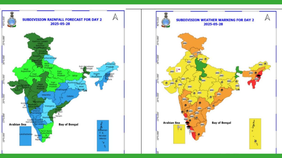
Heavy to very heavy rainfall is expected over Kerala, Mahe, Coastal Karnataka, and South Interior Karnataka, with isolated extremely heavy downpours likely in Kerala. Tamil Nadu, Puducherry & Karaikal are also expected to receive heavy rainfall, accompanied by thunderstorms, lightning, and gusty winds reaching speeds of 40–50 kmph. A thundersquall with wind speeds of 50–60 kmph, gusting up to 70 kmph, is likely over South Interior Karnataka.
Southwest monsoon rainfall over India is expected to be 106 per cent of the Long Period Average, India Meteorological Department said on Tuesday. This projection is more than the 105 per cent forecast in the April update. The Long Period Average rainfall in India is 868.6 mm. The IMD said that above normal rainfall is most likely over the country as a whole during the monsoon season (June to September) 2025.
Catch all the live updates, daily forecasts, and IMD alerts — only on News24.
Mumbai city receives heavy rainfall
#watch | Maharashtra: Mumbai city receives heavy rainfall. Visuals from Wadala area. pic.twitter.com/cYpUgtBext
— ANI (@ANI) May 28, 2025
Heavy Rainfall In Parts Of Haridwar
#watch | Uttarakhand: Haridwar receives heavy rainfall and hailstorm. pic.twitter.com/6j306RVK7T
— ANI (@ANI) May 28, 2025
A Low Pressure Area formed over Northwest Bay of Bengal off Odisha coast in the morning (0830 hours IST) of yesterday, the 27th May 2025. It lay as a Well Marked Low Pressure Area over the same region at 0530 hrs IST and persisted over the same region at 0830 hours IST of today, the 28th May 2025. It is likely to move slowly northwards and concentrate into a Depression over north Bay of Bengal during next 24 hours: IMD.
Subject: Well Marked Low Pressure area over Northwest Bay of Bengal off Odisha coast:A Low Pressure Area formed over Northwest Bay of Bengal off Odisha coast in the morning (0830 hours IST) of yesterday, the 27th May 2025. It lay as a Well Marked Low Pressure Area over the same… pic.twitter.com/mA0DLdoy3f
— India Meteorological Department (@Indiametdept) May 28, 2025
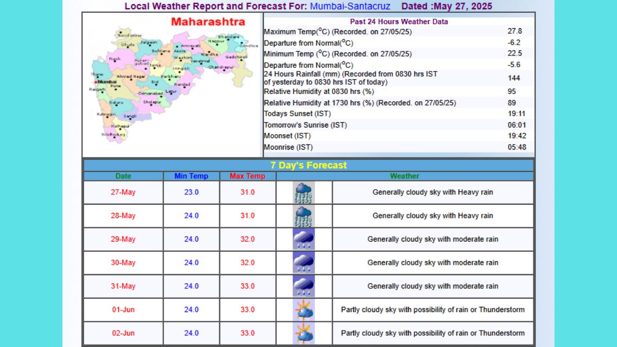
Mumbai: Mumbai will continue to experience cloudy skies with moderate to heavy rainfall on Wednesday, May 28. The weather in the ‘City of Dreams’ has turned pleasant as Mumbai welcomed the first monsoon showers on Monday, May 26. After arriving early in Kerala on May 25, the southwest monsoon advanced towards Karnataka and then Maharashtra. Since then, the state has been receiving heavy showers. Visuals from Khar, Colaba and Marine Drive showed areas drenched in heavy rain. While the rain has turned the weather pleasant, intense downpours have caused waterlogging in various parts of the city, disrupting normal life.
The southwest monsoon seasonal (June to September, 2025) rainfall is most likely to be above normal over Central India and South Peninsular India (>106% of LPA), normal over Northwest India (92-108% of LPA) and below normal over Northeast India (<94% of LPA).
The southwest monsoon seasonal rainfall over the Monsoon Core Zone (MCZ) consisting of most of the rainfed agriculture areas in the country is most likely to be above normal (>106% of LPA). For details pls refer link: https://internal.imd.gov.in/press_release/20250527_pr_4006.pdf
Updated Long Range Forecast for the Southwest Monsoon Seasonal Rainfall during June–September, 2025 and Monthly Rainfall and Temperature Outlook for June 2025.The southwest monsoon seasonal (June to September, 2025) rainfall is most likely to be above normal over Central India…
— India Meteorological Department (@Indiametdept) May 27, 2025
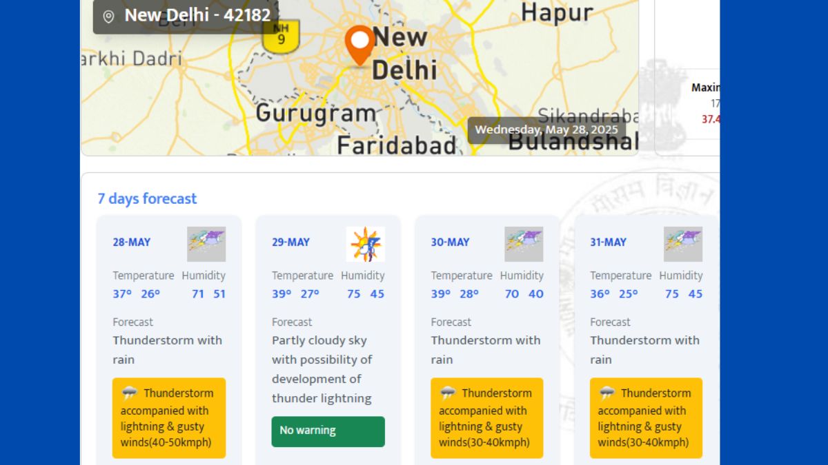
The India Meteorological Department has forecast moderate to heavy rainfall and thundershowers across various regions of Maharashtra:
In Mumbai and surrounding suburbs, expect a generally cloudy sky with moderate to heavy rain, along with the possibility of thunder, lightning, and gusty winds at isolated spots.
Heat wave conditions are very likely in isolated pockets of West Rajasthan on May28, Wednesday.
Get Breaking News First and Latest Updates from India and around the world on News24. Follow News24 on Facebook, Twitter.
---Advertisement---

CAT 2025 Results Declared: 12 candidates score perfect 100 percentile

---Advertisement---