


Heavy Rainfall very likely at isolated places over Arunachal Pradesh, Assam & Meghalaya, Bihar, Chhattisgarh, Gujarat State, Jharkhand, Lakshadweep, Marathwada, Nagaland, Manipur, Mizoram and Tripura, North Interior Karnataka, Odisha, Telangana, Uttarakhand and Vidarbha.
IMD Weather LIVE Updates: The India Meteorological Department (IMD) has forecast widespread rainfall, thunderstorms, and strong winds across several parts of India starting May 25, continuing through the end of the month. Several states across the southern, western, northeastern, eastern, and central regions are expected to witness moderate to heavy rainfall, with some areas likely to receive very heavy to extremely heavy downpours. Heavy rains accompanied by thunderstorms lashed Delhi-NCR on Saturday evening (May 24), leading to severe waterlogging, traffic snarls, and power outages in several parts of the city.
A depression over the east-central Arabian Sea and adjoining south Konkan coast made landfall near Ratnagiri on Saturday, May 24, according to the India Meteorological Department (IMD). The system, which had been moving eastward at a speed of 5 kmph, is now gradually weakening and is expected to transform into a well-marked low-pressure area as it crosses into Madhya Maharashtra over the next 24 hours.
---Advertisement---
Heavy to very heavy rainfall is forecast over Kerala and Mahe from May 25 to 30, with extremely heavy rain at isolated places particularly likely on May 25 and 26. Similarly, Coastal and South Interior Karnataka will continue to receive heavy rainfall through May 27, intensifying further from May 28 to 30. North Interior Karnataka is also expected to receive heavy rainfall during this period.
Catch All the Live Updates, Daily Forecasts, and IMD Alerts at www.news24online.com.
---Advertisement---
IMD Weather LIVE Updates:
Heavy to Very Heavy Rainfall very likely at isolated places over Andaman & Nicobar Islands, Konkan & Goa and Madhya Maharashtra.
Heavy to Very Heavy Rainfall with isolated Extremely Heavy Rainfall very likely at isolated places over Costal Karnataka, Kerala & Mahe, South Interior Karnataka and Tamil Nadu Puducherry & Karaikal.
Weather Forecast For Uttarakhand
•Light to moderate rain / thunderstorm likely to occur at most places in Bageshwar, Pithoragarh, Nainital and Udham Singh Nagar districts and at a few places in Uttarkashi, Tehri and Haridwar districts of Uttarakhand.
•Light to moderate rain / thunderstorm likely to occur at many places in remaining districts of Uttarakhand.
IMD Weather LIVE: Desert Sandstorm Hits Jaisalmer In Rajasthan
Desert sandstorm hits Jaisalmer, continued since last night, reducing visibility.
#watch | Rajasthan | Desert sandstorm hits Jaisalmer, continued since last night, reducing visibilityAn individual says, "... The temperature has reduced significantly this morning; the visibility is very low..." pic.twitter.com/3KEWNkyXK3
— ANI (@ANI) May 25, 2025
Monsoon Hits Kerala Early! Sweeps Swiftly Across Southern States
Monsoon 2025: The wait for the Monsoon in India ended with southwest monsoon making landfall in Kerala on Saturday, May 24. This marked its earliest onset over the Indian mainland since 2009, according to the India Meteorological Department (IMD). The onset of southwest monsoon over Kerala is eight days earlier than its normal onset date of June 1. The IMD had earlier predicted the early arrival of the monsoon on May 27.
IMD Weather LIVE: Rain Lashes Mumbai
Rain lashes parts of Mumbai city as Monsoon arrives in India.
#watch | Maharashtra | Rain lashes parts of Mumbai city as Monsoon arrives in India(Visuals from Mumbai expressway) pic.twitter.com/djnvJXE6SV
— ANI (@ANI) May 25, 2025
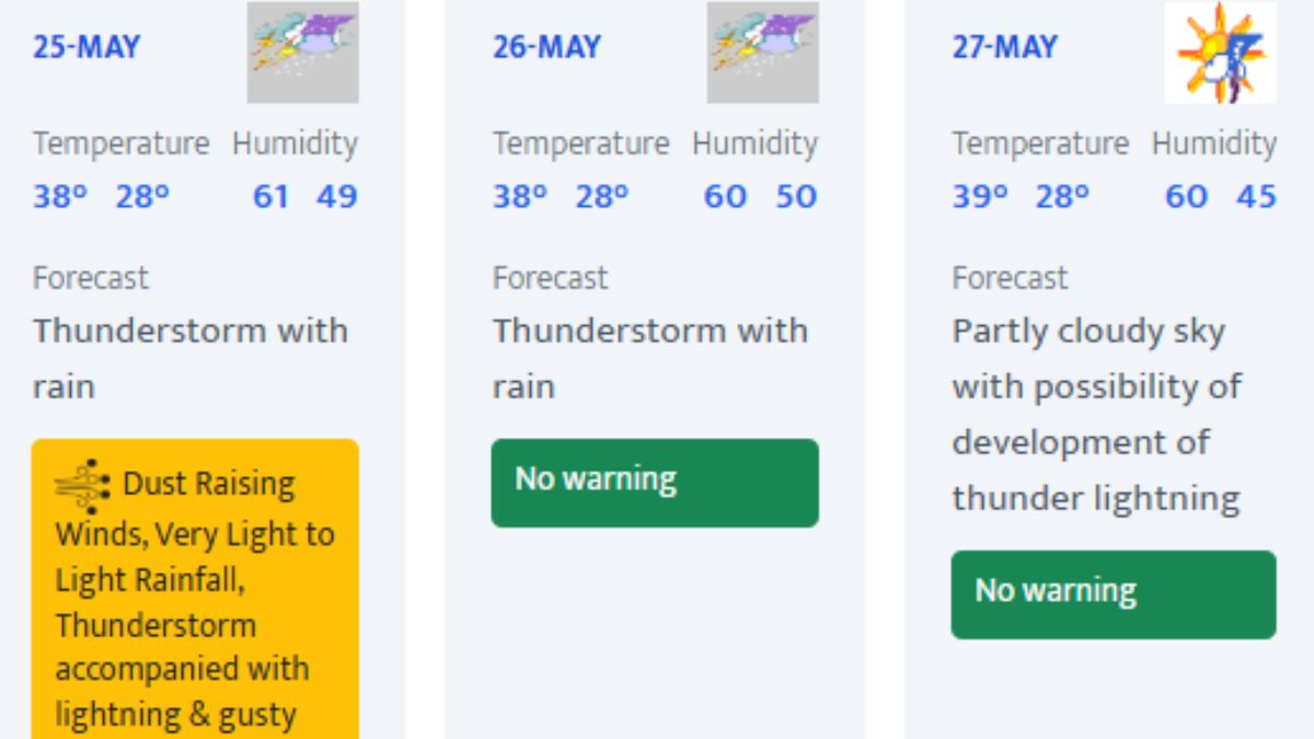
Delhi Weather Forecast: Rain And Thunderstorm To Hit Capital
Dust Raising Winds, Very Light to Light Rainfall, Thunderstorm accompanied with lightning & gusty winds(40-50kmph) have been predicted over Delhi.
• Today’s Maximum temperatures are in the range of 37-38°C.
The sky will remain partly cloudy with possibility of very light to light rain/thunderstorm/lightning and gusty winds (speed 30-40 kmph) temporarily reaching to 50 kmph during thunderstorm.
IMD Weather LIVE: 49 Flights Diverted, Normal Services Restored
Due to adverse weather conditions in Delhi, 49 flights were diverted between 11:30 PM and 4 AM. Normal services restored: Delhi Airport Sources.
Due to adverse weather conditions in Delhi, 49 flights were diverted between 11:30 PM and 4 AM. Normal services restored: Delhi Airport Sources
— ANI (@ANI) May 25, 2025
IMD Weather LIVE: Forecast For Himachal Pradesh
IMD Weather LIVE: Forecast For Uttar Pradesh, Districts On Alert!
The India Meteorological Department (IMD) has predicted rain and thunderstorm activity across several parts of Uttar Pradesh, with warnings of gusty winds and lightning over the next two days.
Forecast for West Uttar Pradesh
There is a possibility of rain or thundershowers at isolated places across the western districts of the state. Additionally, gusty winds with speeds reaching 30–40 km/h may occur in some areas, which could lead to minor disruptions.
Forecast for East Uttar Pradesh
In the eastern parts of the state, isolated rain or thundershowers are also expected. The IMD has issued a thunderstorm and lightning warning, with gusty winds reaching 30–40 km/h likely at isolated locations.
Districts on Alert
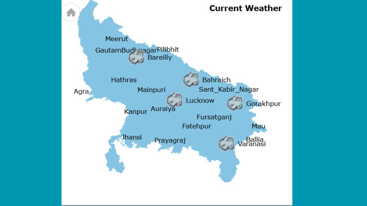
Visual Update: Current Weather Conditions Across Uttar Pradesh
The IMD graphics for current weather over Uttar Pradesh shows rainy spell in several districts.
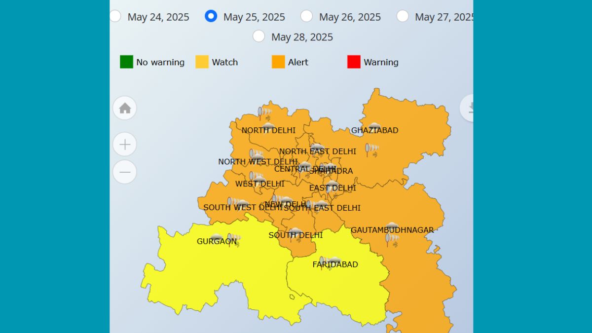
Forecast For Delhi-NCR In Pictures
IMD Weather LIVE: Rainfall Forecast Over Karnataka In Pictures
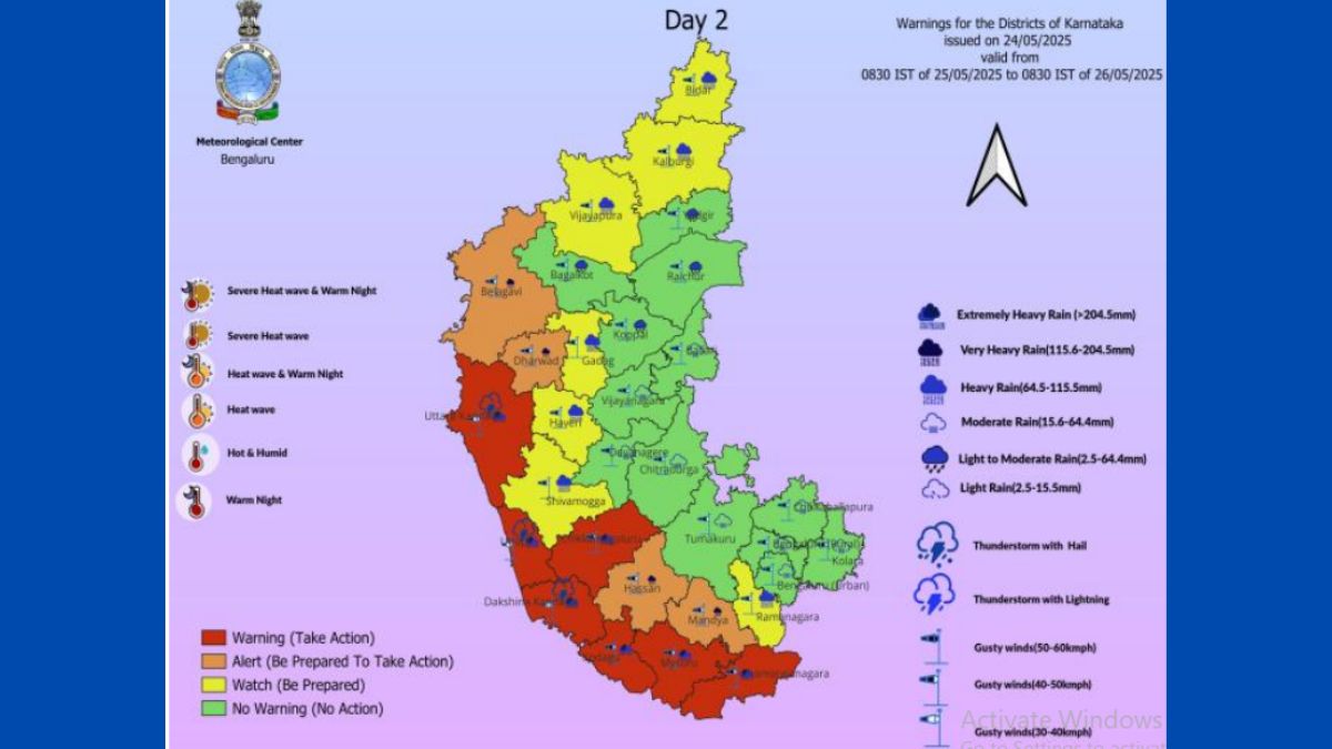
Forecast For Karnataka: Heavy Rain To Lash Belagavi, Dharwad & Other Districts
Depression Near Sholapur Moving East-Northeast, Likely To Weaken in 12 Hours: IMD
The IMD wrote on X, " The Depression over Maharashtra moved nearly east-northeastwards with a speed of 20 kmph during past 6 hours, and laycentred at 2330 Hrs IST of yesterday, the 24th May 2025 over Madhya Maharashtra near latitude 17.5° N & longitude 75.3° E, about 100 km northeast of Sangli ( Maharashtra), 70 km west-southwest of Sholapur (Maharashtra), 110 km southwest of Osmanbad (Marathwada) and 240 km west of Bidar (N. I. Karnataka).It is very likely to continue to move nearly east-northeastwards across south Madhya Maharashtra, Marath ext 12 hours."
The Depression over Madhya Maharashtra movednearly east-northeastwards with a speed of 20 kmph during past 6 hours, and laycentred at 2330 Hrs IST of yesterday, the 24th May 2025 over Madhya Maharashtranear latitude 17.5° N & longitude 75.3° E, about 100 km northeast of… pic.twitter.com/xcyLhrHWyL
— India Meteorological Department (@Indiametdept) May 24, 2025
Delhi Airport T1 Area Flooded After Heavy Rains
Severe waterlogging witnessed in parts of Delhi following heavy rainfall. Visuals Show Flooded Roads Near Airport T1.
#watch | Severe waterlogging witnessed in parts of Delhi following heavy rainfall(Visuals from near Delhi Airport Terminal 1) pic.twitter.com/qLirfoXhRw
— ANI (@ANI) May 24, 2025
IMD Weather LIVE: Nanakpura Underpass Flooded Following Intense Rain In Delhi
Waterlogging witnessed in Nanakpura Underpass following heavy rainfall on Sunday.
#watch | Delhi: Waterlogging witnessed in Nanakpura Underpass following heavy rainfall pic.twitter.com/JQ2lag2EFX
— ANI (@ANI) May 25, 2025
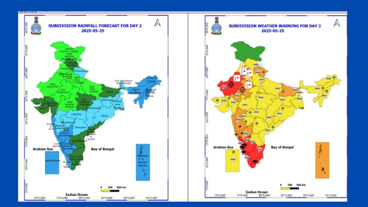
IMD Weather LIVE: Key Weather Highlights For May 25
IMD Weather LIVE: Rainfall Forecast In Pictures
IMD Weather LIVE: Dust Storm To Sweep Rajasthan, Heatwave Condition Over Punjab
Red Alert For Fishermen And Coastal Activities
Authorities have issued strict warnings to those in maritime and coastal regions:
IMD Weather LIVE: Strong Wind Alert!
Wind speeds of 45–55 kmph gusting to 65 kmph are expected over the Eastcentral & South Arabian Sea, Lakshadweep, Comorin area, and along & off the coasts of Kerala, Karnataka, Konkan-Goa, and parts of Gujarat until May 25
Depression Crosses Konkan Coast Near Ratnagiri; IMD Issues Rainfall Warnings
A depression over the east-central Arabian Sea and adjoining south Konkan coast made landfall near Ratnagiri on Saturday, May 24, according to the India Meteorological Department (IMD). The system, which had been moving eastward at a speed of 5 kmph, is now gradually weakening and is expected to transform into a well-marked low-pressure area as it crosses into Madhya Maharashtra over the next 24 hours.
IMD Weather LIVE: Forecast For East And Central India
IMD Weather LIVE: Rain To Lash Assam - Check Forecast For Northeast India
IMD Weather LIVE: Forecast For West India
Coastal Maharashtra, Goa, and the Ghat areas of Maharashtra are bracing for heavy to very heavy rainfall from May 25 to 30, with extremely heavy rainfall at a few places.
The Gujarat region and Marathwada will also see scattered rainfall during May 25 to 27, with high wind speeds forecast for May 25.
IMD Weather LIVE: Forecast For Southern States
Widespread Rainfall, Thunderstorms And Strong Winds Forecast Across India From May 25
The India Meteorological Department (IMD) has forecast widespread rainfall, thunderstorms, and strong winds across several parts of India starting May 25, continuing through the end of the month. Several states across the southern, western, northeastern, eastern, and central regions are expected to witness moderate to heavy rainfall, with some areas likely to receive very heavy to extremely heavy downpours.